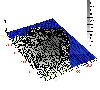
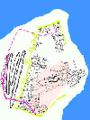
| Date | Dist. 1 | Dist. 2 | Dist. 3 | (All distances are approximated) |
| 1934 | 85 m. | 65 m. | 75 m. | Dist. 1 = distance Tower A - Sinoe lake shore line. |
| 1953 | 60 m. | 42 m. | 50 m. | Dist. 2 = distance "fracture" late Roman city wall (East) - Sinoe lake shore line. |
| 1981 | 27 m. | 13 m. | 17 m. | Dist. 3 = distance Pârvan's sondage for the east side of the late Roman city wall (that
correspond to a point between the C and D towers on the western flank of the late
Roman city wall) - Sinoe lake shore line. |
|
These results have three major implications:
 a. - interpreting the descriptions of the site given by the reports of Pârvan and Lambrino must take this fact
into account. a. - interpreting the descriptions of the site given by the reports of Pârvan and Lambrino must take this fact
into account.
b. - the difficulties encountered in locating the excavation conducted by Pârvan [4] in the area called today
"Temple Sector" are also due to the modification - in this area - of the coast line with more than 50 m., i.e.
most of his 200 m2 area must be now covered by the lake.
c. - the reported "wall" or "dike" that would be some 50 m to the east of the coast line - now covered by the
water of Sinoe lake - roughly correspond to the old coast line. Even the presumed orientation of this structure
(approx. NE-SW) could be explained by the old coast line that look like there has a small gulf just in face of
the Temple sector (the second gulf was placed on the other side of the "Domus" promontory).
For the final result we preferred to use the level map - with a slightly corrected coast line - because it offers an easier way to
control planar co-ordinates.
All these difficulties and results gave us more reasons to intensify our efforts for implementing at Histria a GIS intended to cover
the whole area of the ancient site.
| |
[4] V.Pârvan, Raport provizoriu asupra primei campanii de sãpãturi la Histria, in Anuarul Comisiunii Monumentelor Istorice pe
1914, Bucureti, 1915, p. 19,22 and 26.
|
Main results
We shall now, very briefly, consider the main results of this research for the space usage in the main areas of the site.
|
|
SACRED AREA
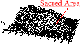 Perhaps the most surprising and important result of this research is concerning this area, placed in the
north-eastern part of the site.
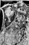
Pârvan's presumption about the existence of Greek temples led to an excavation in the area. After WW2
the archaeological researches conducted here confirmed the presence of one of the sacred areas of the site. Unfortunately, no
information survived on the location and results of the old excavations. There is no way that we could identify the placement of
this excavations as we are unable to locate on the terrain the city wall "fracture" mentioned by Pârvan in the area [5]. However,
the re-discovery of the Late Roman city wall in the course of recent archaeological researches and its supposed traject seem to
confirm that the "fracture" is to be placed in the area immediately to the east of the altar D. Future researches in the area are
supposed to uncover the late Roman city wall on a longer distance to the north [6].
The main result of this research is that the three dimensional model of the cliff put in evidence,too, the fact that the "Sacred
Area" is not on the Acropolis. We used to consider, because of the general spread idea of the usual placing of the cult
monuments on the Acropolis of the Greek cities [7], that Histria's sacred area is not an exception to this rule and most of the
publications are referring to it as being placed on the Acropolis of the city [8]. As our three dimensional model is showing, the
platform surrounding Aphrodite's temple is approx. 3 m lower than the highest area of the city placed some 50 m. to the south.
The questions that first come to one's spirit is: what have determined the placement of the "Sacred Area" here, in one of the
lowest areas of the Greek city ?
In our opinion, an acceptable explanation of this situation could be the deep depression located immediately to the east of the
platform of the Aphrodite's temple. Of course, the sacred character of this cavity
is only to be supposed and the lack of stratigraphical information contained by the publications that refer to the excavations
made in this area are not making things easier.
As our 3D model is showing, the shape of the cliff could be an answer to the questions risen by the non-continuity of the use of
the sacred space at Histria: there is no trace of superposition of the Greek sacred monuments by early Roman temples and
perhaps the Roman temples - and other Greek temples as well [9] - are to be found on the highest area of the city. Perhaps the most surprising and important result of this research is concerning this area, placed in the
north-eastern part of the site.
Pârvan's presumption about the existence of Greek temples led to an excavation in the area. After WW2
the archaeological researches conducted here confirmed the presence of one of the sacred areas of the site. Unfortunately, no
information survived on the location and results of the old excavations. There is no way that we could identify the placement of
this excavations as we are unable to locate on the terrain the city wall "fracture" mentioned by Pârvan in the area [5]. However,
the re-discovery of the Late Roman city wall in the course of recent archaeological researches and its supposed traject seem to
confirm that the "fracture" is to be placed in the area immediately to the east of the altar D. Future researches in the area are
supposed to uncover the late Roman city wall on a longer distance to the north [6].
The main result of this research is that the three dimensional model of the cliff put in evidence,too, the fact that the "Sacred
Area" is not on the Acropolis. We used to consider, because of the general spread idea of the usual placing of the cult
monuments on the Acropolis of the Greek cities [7], that Histria's sacred area is not an exception to this rule and most of the
publications are referring to it as being placed on the Acropolis of the city [8]. As our three dimensional model is showing, the
platform surrounding Aphrodite's temple is approx. 3 m lower than the highest area of the city placed some 50 m. to the south.
The questions that first come to one's spirit is: what have determined the placement of the "Sacred Area" here, in one of the
lowest areas of the Greek city ?
In our opinion, an acceptable explanation of this situation could be the deep depression located immediately to the east of the
platform of the Aphrodite's temple. Of course, the sacred character of this cavity
is only to be supposed and the lack of stratigraphical information contained by the publications that refer to the excavations
made in this area are not making things easier.
As our 3D model is showing, the shape of the cliff could be an answer to the questions risen by the non-continuity of the use of
the sacred space at Histria: there is no trace of superposition of the Greek sacred monuments by early Roman temples and
perhaps the Roman temples - and other Greek temples as well [9] - are to be found on the highest area of the city.
| |
[5] See C. Domãneantu, A. Sion, Incinta romana tirzie de la Histria.Incercare de cronologie, in SCIVA,1982 (4), pp.
377-394, for a comprehensive account of the researches on the late Roman city wall and the bibliography of the subject.
[6] We wish to thanks to Al. Avram for the permission to collect topographical data resulted from the recent excavations.
[7] Of course, temples are not to be found only on the Acropolis of Greek cities. For few of the many examples, see W.
Hoepfner and E-L. Schwandner, Haus und Stadt im Klassischen Griechenland, p.145 (Priene) and p. 188 (Halikarnassos).
[8] E.g., Histria I, p. 231, p. 20, P. Alexandrescu, Histria in archaischer Zeit, Xenia 25 (1990), p.52.
[9] M. Lambrino, Les vases archaiques d'Histria, 1938, pp. 356-357, supposed the existence of a temple dedicated to Apollo
|
CENTRAL AREA
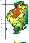 As our measurements are showing the central area of the late Roman city is higher than the rest of the site.
Of course, the continuous inhabitancy of the area since the beginning of the Greek colony led to an important
accumulation of anthropologic deposits - approx. 6 m. high. On the other hand the excavations conducted in
this area didn't descend, but accidentally [12], under the layers of the VIth c. AD.
The main monument uncovered in this area is the impressive Bishopric basilica - built during the reign of
Justinian. **trimitere la articol Dacia Suceveanu** The dimensions (length = 67 m., width = 30 m.) and the
monumentality of the remains of this basilica will not allow further researches of the lower layers - with the
exception of some small size sondages.
One of the sondages was made by the author of this study. The result was that it permitted the observation that the exterior
walls of the basilica descended and rested directly on the cliff. From the stratigraphical point of view the situation can be
summarised by the fact that there were identified all the Greek and Roman layers known from the excavations made in other
points of the site, from the Greek archaic age down to the last Roman layer of the city. An other important result, despite the
reduced size of the sondage (4 x 2 m.) was that no trace of decapation could be observed in this area the layers succeeding in
the most natural order. Of course, further sondages that will be conducted in connection with the excavation in course of the
Bishopric basilica will bring new data that will help having a better image of the buildings lying under this monument. Our
sondage did not offer any indications of important Greek buildings, but its size was - evidently - not permitting the observations
that could be made in the case of a surface research.
If we accept the idea that the Acropolis (in its urbanistical acceptation) is to be identified with the highest area of the cliff ,
found in the centre of the late Roman city, then we should suppose that the area surrounding the Bishopric basilica (which is
superposing an earlier basilica ) could -- in that case -- overlay some of the main monuments of the Greek city. According to
the "law" of the continuity in the urban space usage, if the Bishopric basilica of the VIth c. AD is built on the same place as an
earlier (and smaller) basilica of the IVth c. AD we should suppose that these monuments were built over other older religious
buildings. It is evident that this hypothesis is to be confirmed by future excavations.
As our measurements are showing the central area of the late Roman city is higher than the rest of the site.
Of course, the continuous inhabitancy of the area since the beginning of the Greek colony led to an important
accumulation of anthropologic deposits - approx. 6 m. high. On the other hand the excavations conducted in
this area didn't descend, but accidentally [12], under the layers of the VIth c. AD.
The main monument uncovered in this area is the impressive Bishopric basilica - built during the reign of
Justinian. **trimitere la articol Dacia Suceveanu** The dimensions (length = 67 m., width = 30 m.) and the
monumentality of the remains of this basilica will not allow further researches of the lower layers - with the
exception of some small size sondages.
One of the sondages was made by the author of this study. The result was that it permitted the observation that the exterior
walls of the basilica descended and rested directly on the cliff. From the stratigraphical point of view the situation can be
summarised by the fact that there were identified all the Greek and Roman layers known from the excavations made in other
points of the site, from the Greek archaic age down to the last Roman layer of the city. An other important result, despite the
reduced size of the sondage (4 x 2 m.) was that no trace of decapation could be observed in this area the layers succeeding in
the most natural order. Of course, further sondages that will be conducted in connection with the excavation in course of the
Bishopric basilica will bring new data that will help having a better image of the buildings lying under this monument. Our
sondage did not offer any indications of important Greek buildings, but its size was - evidently - not permitting the observations
that could be made in the case of a surface research.
If we accept the idea that the Acropolis (in its urbanistical acceptation) is to be identified with the highest area of the cliff ,
found in the centre of the late Roman city, then we should suppose that the area surrounding the Bishopric basilica (which is
superposing an earlier basilica ) could -- in that case -- overlay some of the main monuments of the Greek city. According to
the "law" of the continuity in the urban space usage, if the Bishopric basilica of the VIth c. AD is built on the same place as an
earlier (and smaller) basilica of the IVth c. AD we should suppose that these monuments were built over other older religious
buildings. It is evident that this hypothesis is to be confirmed by future excavations.
| |
[12] O. Bounegru, in La politique édilitaire dans les provinces de l'Empire Romain, Actes du Ier Colloque Romano-Suisse,
Deva, 1991, Cluj, 1993, p. 195 - 200.

|
|
"PÂRVAN" BASILICA
 It is now obvious that the "Pârvan" basilica is placed on the southern border of the Acropolis. This could be
an other reason for which Ms. Lambrino's theory on placing here Histria's most important and greatest Greek
sanctuary - the one dedicated to Apollo Ietros - is to be reconsidered.
If - as it is now presumed - the port was placed somewhere to the south of the city its position would have
been as close to the port as close was Apollo's temple in Histria's mother city - Miletus [13]. The same
placement of the Apollo temple, on the border of the sea is encountered in Rhodes [14]
Also, it would be a very interesting situation because we would have - for the first time at Histria - a Greek temple superposed
by a Roman basilica.
Of course, an ultimate confirmation is to be found only by re-opening the old excavations and, thus, verifying the conclusions
that led M. Lambrino to her conclusions. It is now obvious that the "Pârvan" basilica is placed on the southern border of the Acropolis. This could be
an other reason for which Ms. Lambrino's theory on placing here Histria's most important and greatest Greek
sanctuary - the one dedicated to Apollo Ietros - is to be reconsidered.
If - as it is now presumed - the port was placed somewhere to the south of the city its position would have
been as close to the port as close was Apollo's temple in Histria's mother city - Miletus [13]. The same
placement of the Apollo temple, on the border of the sea is encountered in Rhodes [14]
Also, it would be a very interesting situation because we would have - for the first time at Histria - a Greek temple superposed
by a Roman basilica.
Of course, an ultimate confirmation is to be found only by re-opening the old excavations and, thus, verifying the conclusions
that led M. Lambrino to her conclusions.
| |
[13] For the placement of the milesian sanctuary dedicated to Apollo Delphinion on the border of the Lions Harbour see W.
Hoepfner and E-L. Schwandner, op.cit., p.9 and 11.
[14] W. Hoepfner and E-L. Schwandner, op.cit., p.23,
|
|
SOUTH-WEST AREA This area is much lower than the rest of the late Roman site. Even lower seems to be that quarter of the city
that was attached during the IVth c. AD (phase II B of the Roman city). The ramp of the streets of this area
seem to follow the shape of the cliff . The excavations conducted here stopped on the late layers of the
occupation and show no trace of any structure that would have marked somehow an urbanisticalal distinction
between the old quarters and the new one. However, the shape of the soil is quite *** here. We should add
that it was demonstrated - by recent excavations - that this "economical" quarter is lying directly on the
ancient sand of the gulf existing at that time to the south of the city.
|
|
THE WESTERN AREA
The western front of the late Roman city-wall is placed outside the high area of the city. This part of the city
wall is placed over the Hellenistic layers [15] - which demonstrates that in the Hellenistic age these layers
were lower than the rest of the city.
Prof. D. Adamesteanu informed about the existence - in the civilian basilica placed just across the city-wall
tower G - of a huge wall, running parallel to the tabernae walls, found at a depth that was making him think it
was Greek [16]. If there are urbanistical reasons [17] to presume the existence in this area of a wall the same
is to be said about the topographical reasons: if the wall exists it is most probable to follow the ridge of the
high area of the centre of the Greek city. The supposed urbanistical function of this wall - assumed by Al. Suceveanu [18] - is
still to be revelled by the planned excavation.
| |
[15] Gr. Florescu, Histria I, p.119.
[16] Partially the same information at Gr. Florescu, Histria I, p.115.
[17] Trimitere Monica
[18] Al. Suceveanu, Histria - bilant si perspective??, in SCIVA, p.??????
|
THE MAIN MARKET
The depression was visible even before V. Pârvan started the excavations in Histria [19] - that mean before
"cleaning" the late Roman walls mentioned to have existed here. The sections made in 1944 demonstrated that the actual soil is very close to that
of the cliff. This situation imposed (as seen in the Domus area) massive demolition in the moment of construction of the
Roman monuments of the area. The same sections showed that in the civilian basilica all the underlying levels
were destroyed by the Roman construction. The foundations of the basilica are descending to the cliff, that
was levelled.
| |
[19] V.Pârvan, in Boabe de grâu, p. ; Buletinul Comisiunii Monumentelor Istorice, p.
|
|
"B" AREA (north-east)
There is no available data for this area because of the very few excavations made here only before the World War II.
In conclusion, we have tried to prove that a new approach of an old problem -- the Histrian topography -- can bring
new and maybe unexpected solutions. We hope that the fact the solutions are rising more new questions will not be
considered as guilt of the author.
|
|